Showing posts with label nws. Show all posts

Friday, April 13, 2012

Point of Attack

Today we left nowhere and are still nowhere in Wichita Kansas. Its amazing how you can drive for 300 miles and the scenery really doesn't change, but at the same time its so different and beautiful. The rolling hills of Nebraska and Kansas are incredible, as well as the towns. We drove through one town called Stockton today and all I could picture were scenes from Twister. It was a really cool town though, very small and quite "cute" for lack of a better word. Then after settling in in Wichita we decided to have a real meal for once and went to a place called Granite City Brewery. It was like the Ram for those who know what I am talking about, literally. Same food choices, same kinds of beer, just a different state. It was great too. We were treated like royalty while we were there. Once they found out we were from Seattle only there to chase storms we had people walking up to us all night. But now I turn to our storms.

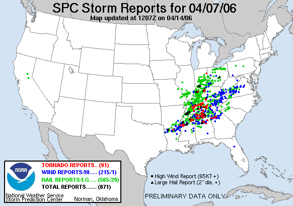
It has made National News and when I sat down tonight to do some homework, I pulled up yahoo, and there was the headline. How bad is it? I guess we will find out tomorrow, and all I know is that last time the National Weather Service gave "high risk" 24 hours in advance was in April of 2006, where over 91 tornadoes touched down and it stretched across 13 states.

http://en.wikipedia.org/wiki/April_6%E2%80%938,_2006_tornado_outbreak

Tomorrow, the storms should start forming along the dryline at around 3-4PM, so it will be a waiting game and placement. Right now though, "high risk" has been issued from Salina KS, down to Oklahoma City. Wichita is right in the middle. Thats all for now Ill try and post in the morning an exact location of where we will be, also look for pictures! Hopefully of some tornadoes...

High Risk... High Reward

It is day three and of course we had to stop at a Starbucks, not only for some coffee but internet to do some work. Yesterday we drove just over 1,200 miles to get to North Platte, Nebraska. We traveled out of Montana and the Rocky Mountains down into the beautiful plains of Wyoming. It is such an easy drive because the speed limits are so ridiculously high... When speed limits are 75 its so easy to set the cruise control right at 82. The car has held up great so far. Now to storms....
Wyoming
Yesterday as we were filling up with gas I was checking some stuff on my phone and saw the town we were headed to was Tornado warned... Unfortunately it was already dark and we were still two hours away, but now I know we are in the right area. A bit of a lightning show the last 2 hours as we drove and got our adrenaline going as we pulled into town.

However today as I woke around 8AM (not sure what time zone, 2 hr difference) was checking the SPC, NOAA and a couple other sites and saw that the storms were tracking farther east than anticipated. Unfortunately we would have had to drive to Kansas City/ middle parts of Missouri for a less than 10% chance of seeing anything. After a couple more hours of sleep I checked again and realized that tomorrow, Saturday, is setting up to be a record breaking type day. Not to alarm anyone but it is what is considered a "High Risk" outlook.
http://www.spc.noaa.gov/products/outlook/day2otlk.html
What does this mean? Alot... Four major cities (Oklahoma City, Wichita, Omaha, Kansas City) are in the cross hairs for what could be a deadly day. We have already decided to drive to Wichita tonight to set up camp and then drive to an open area with a large road network away from any cities or debris for our chase day. We are going to take precautions tomorrow because with a day like this, safety first.

Secondly this is what they consider to be a outbreak day, or multiple tornadoes. How many? Well for reference the last time a "high risk" was posted a day in advance was in April 7th 2006 where over 91 tornadoes spawned stretching 9 different states.

I don't think that we could have picked a better weekend to be chasing. (Sorry mom). Ill post again tonight to give a target area of where we will be in the morning.

Thursday, April 12, 2012

It is day two of the adventure and we have stopped in Butte Montana for some Starbucks and internet. Other than a small hiccup and a sleep stop this morning we have been making great time. The storms look like they are tracking a bit farther north tomorrow which benefits our chase day. Instead of driving south through Colorado we will be heading east into the western tip of Nebraska where we will have a nice set up for tomorrow. We still have alot of driving ahead of us. Sadly tomorrows storms are just a precursor to Saturday where they could experience outbreak tornado activity. Ill try and update tonight as the model runs come in so I can give a target area of where we should be.

Wednesday, April 11, 2012

So with my minimal amount of school this week, and optimal set up for severe weather over the great plains. I couldn't think of a better weekend to do something that I have wanted to do for years. Tonight around 9PM, me Andrew Knutzen and Trevor Herndon, will be driving for the border of Colorado and Kansas and might drive as far east as Dodge City, Kansas to chase some tornadoes. Things are setting up really nicely for tornadic activity Thursday-Saturday. There is strong shear, which is cross winds at different elevations, and a very defined dry line, which is an area where there is high dew points to the east then following behind to the west much lower. These are two key ingredients which will be key for Thursday and Friday's set up. The dry line is usually where storms tend to fire off. We are going to drive I-90 to Montana then head south through Wyoming and Colorado and finally into Kansas where we will set up shop.
Ill try and update this at least once a day for people who want to follow my travels and hopefully I will be able to post some pictures like the one above soon! Also please excuse my spelling and punctuation, Ill clean it up when I return.